Seamantix comes without data; chart subscriptions are available in-app.
Full specs and more screenshots: http://www.satellite25.com/seamantix.html
Chart list: http://www.satellite25.com/charts.html
AVAILABLE DATA
- USA: NOAA (ENC)
- The Netherlands (IENC)
- Belgium (IENC)
- Germany (IENC)
FEATURES
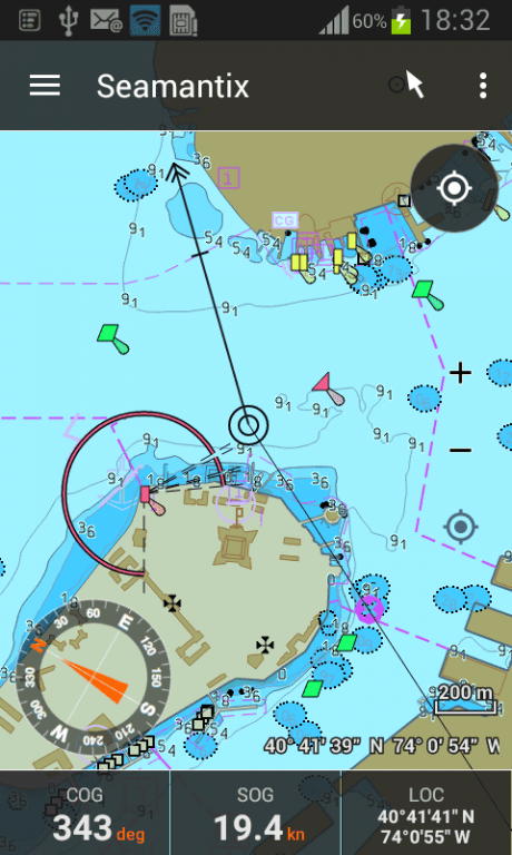
MAP ENGINE
- ENC vector charts, rendered crisp, pixel-perfect on all scales
- visualization compliant with the IHO (S-52) and IENC specifications
- charts (depth areas, safety contours and underwater hazards) are colored according to your vessel's draft
- add tidal info: adjust chart depths and coloring to actual water level
- simplified and paper chart icon sets
- 3 color schemes (day/dusk/night) for optimal brightness
- filters: display categories, soundings, land areas, labels, metadata
- map operations: zoom in/out, panning, distance measurement
DATA
- easy chart installation via the built-in map manager
- all charts come with detailed attribute info of the map features, e.g.: buoy shape/type/name, light patterns, fog signal patterns, wreck depth, …
- background data: OpenStreetMaps (requires a network connection)
NAVIGATION AND ROUTES
- show current position in real-time using GPS
- compass: true and magnetic north
- center-map-on-vessel mode
- define routes (waypoints + legs)
- configure max cross-track-error and planned speed per leg
- speed vector (COG + SOG)
- bearing line from vessel to next waypoint
- heading line
- automatically advance to next waypoint when entering waypoint arrival circle
- navigation panel: configurable matrix of parameters (1x1 up to 10x10)
- supported navigation parameters: ALT, ASOG, BOD, BTW, CMG, COG, DMG, DOD, DPT, DTE, DTG, DTW, ETA, HDG, LAT, LOC, LON, MSOG, SOG, TIME, TIT, TMT, TOD, TTG, TTT, VMC, WLOC, WLON, WLAT, WPT, XTE
- monitor anchorage area
- routing notifications: via Android notification system and Android Wear
TRACKS
- continuous track recording
- log book: automatic recording of events (waypoint reached, distance progress, anchorage, alarms, …)
- plus manual logging of weather reports, fuel levels, engineering issues, …
SAFETY SYSTEM
- continuously monitoring of the vessel's safety
- Depth alarms: when approaching or entering shallow waters (distances and depths configurable)
- Route alarm: when deviating from route (distance configurable per leg)
- Anchorage alarm: when drifting away from the anchorage location (distance configurable)
- Man-Over-Board (MOB) mode
- Notifications: on map (visual), via Android’s notification system (visual+auditive), or via Android Wear
ENVIRONMENTAL INFO
- sunrise and sunset times
- available times: official, civilian, nautical and astronomical sunrise/sunset/twilight
SHARING/EXPORTING
- generate route and track reports as PDF, including waypoints, a map, route/track metadata, and the full log book with all events
- events can be filtered to generate specialised reports
- generate screenshots from the current route, track or map to share via e-mail, Facebook, Twitter, Google Drive,…
- import or export routes and tracks as GPX
UNITS
- Location: lon/Lat, UTM
- Length: metric, miles, nautical miles
- Speed: kilometers/hour, meters/second, minutes/kilometer, miles/hour, knots
- Time: 12h, 24h
- Temperature: celsius, fahrenheit, kelvin
- Volume: liter, US gallon, imperial gallon
ANDROID WEAR INTEGRATION
- notifications on Android Wear: navigation instructions, safety alarms
We do not host Seamantix on our servers. We did not scan it for viruses, adware, spyware or other type of malware. This app is hosted by Galad and passed their terms and conditions to be listed there. We recommend caution when installing it.
The APK Download link for Seamantix is provided to you by apps112.com without any warranties, representations or guarantees of any kind, so access it at your own risk.
If you have questions regarding this particular app contact the publisher directly. For questions about the functionalities of apps112.com contact us.

|
| ||||
| Downloads: 11 | ||||
| Updated At: 2024-04-19 20:46:48 | ||||
| Publisher: Satellite25 | ||||
| Operating System: Android | ||||
| License Type: Free |